Image
401 Lake St. Courtesy of Tompkins County Department of Assessment

401 Lake Street - Report by Jessica Geary

Image
401 Lake St. Courtesy of Tompkins County Department of Assessment

401 Lake Street was an 840 square foot one-bedroom single-family dwelling, located on a 2,400 square foot lot, in the Fall Creek neighborhood, dating back to the early 1900s. Before demolition, the property sat on the edge of the Fall Creek Gorge. The owner also owned the undeveloped land adjacent to the lot, which has a lot size of 28,000 feet. The last property owner on record, bought the house in 1990 for $64,900. The owner moved out of the home and established it as a rental. The property would later be abandoned. The owner stopped paying taxes resulting in $18,382.28 of debt for the lot with the house and $6,991.79 for the adjacent undeveloped lot (Crandall, 2016). Due to tax debt and abandonment of the property, the county possessed both lots sometime in 2015. Ultimately, the city bought the property, paid for the delinquent taxes on June 4, 2015, and later demolished the house. 

Plans relative to the site

Image
401 Lake St. Courtesy of Tompkins County Department of Assessment

The comprehensive plan, zoning maps, and environmental assessment gives context in understanding the site and its ultimate fate. The City of Ithaca’s comprehensive plan influenced the fate of this property (Edmonds et al., 2015). The plan, adopted in 2015, highlights residents' vision for future planning in the city and the change they want to see. The document highlights fundamental components, such as community well-being, natural resources, and infrastructure, amongst others. The comprehensive plan and its goals fed into clashes in the decision-making process regarding what to do with the site. Likewise, future zoning maps were also critical in determining what the current and future land use will or should look like, which heavily guided the site's development (City of Ithaca, 2015b). Lastly, the city’s environmental assessment process is critical to understand the possible environmental impacts of a potential new construction or deconstruction (City of Ithaca, 2016).

Image
401 Lake St. Courtesy of Tompkins County Department of Assessment

Image
Zoning map showing 401 Lake Street

Land Use and Zoning Regulations and Design Guidelines

Image
Zoning map showing 401 Lake Street

The zoning regulation before the demolition of the house and its adjacent lot was R-3b, and its land use was classified as a large lot residential (Urban Footprint, 2021). R-3b zoning allows for example single-family or two-family detached dwellings, group housing, or apartment buildings (City of Ithaca, 2015b). After demolition, two adjacent parcels were changed to P-1 zoning and their land use was classified as parks and open space. Fall Creek is designated as a New York State Recreational River and is classified as a recreational overlay zone (City of Ithaca, 2016).

There are limited design guidelines for the site located in Fall Creek. The Fall Creek neighborhood does not have an individual plan. Likewise, historic design guidelines are not applicable for the site since it is not nationally, within the state, or locally registered as a historic property. The property was not in a historic district.

Parcel Neighborhood and Historical underpinnings

Image
Google Earth view of the Fall Creek Neighborhood in Ithaca, New York

The two relevant parcels reside in the Fall Creek neighborhood and are surrounded by different land uses. The neighborhood consists of many one to two-family detached lots that house families and Cornell University graduate students. The majority of homes in the neighborhood and those across the street from the two lots have a zoning ordinance of R-2b and have various land uses. Land uses include but are not limited to suburban mixed residential and residential subdivisions (Urban Footprint, 2021). Overall, the majority of neighborhood properties have well-kept buildings and lawns. The Cliff Side Terrace Apartments lie on a ridge overlooking the undeveloped parcel. The apartments have a zoning code of R-3b, and it's land use is identified as a large lot residential space (Urban Footprint, 2021). Across the street from the parcels is Ithaca High School, which has a zoning code of P-1 and it's land use is classified as office/industrial(Urban Footprint, 2021). Of significant importance is Ithaca Falls, which the property sits next to and has a zoning code of P-1. The fall's land use is classified as park space (Urban Footprint, 2021). 

The land surrounding Fall Creek is rich in a manufacturing history that dates back to the 1800s. The Fall Creek Milling Company, the Ithaca Paper Company, and the Ithaca Gun Company all at one point utilized the power of Ithaca Falls. These manufacturing hubs were found along the creek edge and were located on the opposite side of the two lots.

In the 1800s, visitors of Ithaca Falls interested in hiking to Triphammer Falls and Beebe Lake would start their hike at a "tollbooth" located on 401 Lake Street (O’Connor, 2017). The recently demolished house dates back to the early 1900s, and analysis indicates that no remains of the original tollbooth structure existed inside the house. However, a stone structure on the lot is a remnant of the trail that once existed(O’Connor, 2017). As stated above, the house is not of historical significance.


Image
Google Earth view of the Fall Creek Neighborhood in Ithaca, New York

Proponents for selling the property 

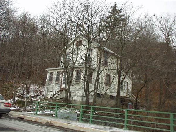
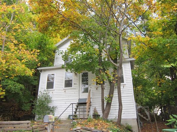
Those in favor of selling the property had various rationale and used the comprehensive plan to support their argument. For one, the cost of demolition and asbestos removal could cost up to $25,000 or more (Crandall, 2016). One city official concluded that the house is salvageable, has a solid foundation, and aligns with the comprehensive plan (Wheeler, 2016). Second, the lot will continue to be on the city tax roll, benefitting the county and school district through generating revenue. Lastly, if the property is sold at the auction, then the city will receive the sales revenue (Crandall, 2016). 

Proponents further state that the comprehensive plan envisions establishing more affordable housing due to high housing costs and a severe housing shortage. In the city, the cost of housing has increased substantially. According to the plan, “Over half all renters in Ithaca pay more than 30 percent of their income to housing, as do 20 percent of all homeowners” (Edmonds et al., 2015). The city's goal is to increase the availability of affordable housing in all neighborhoods of Ithaca and to create more of it. One representative indicated that this house holds potential as an affordable home due to its low market price and it's location near schools and restaurants (Wheeler, 2016).

Proponents for the demolition of the house

Proponents of demolishing the building are based on the zoning regulations of the river and the comprehensive plan. The recreational river zoning regulations prohibit new residential construction within 150 feet of the creek. However, existing structures are allowed to stand, and if the structure is expanded, it can only be extended up to 500 square feet (City of Ithaca, 2016). If demolition were to occur, it would be increasingly difficult to build anything new due to the recreational river zoning regulations. Most importantly, the undeveloped adjacent property could not be developed because the perimeter of the lot is within 150 feet of the creek (City of Ithaca, 2015a).

Aside from the challenges to build-out due to the river zoning regulation, many proponents use the city’s comprehensive plan to support turning the lot into a natural area. The city’s vision for future land use indicates that locations with unique sensitive natural features will not have new development occur on it (Edmonds et al., 2015). Under the "Natural and Cultural Resources” section, the city indicates its desire to preserve and enhance existing natural resources, especially as the city continues to densify (Edmonds et al., 2015). Furthermore, one of the major goals in this section is to continue to protect the gorges as “...critical natural assets for current and future use” (Edmonds et al., 2015). For these reasons, proponents of the park conclude that selling and renovating the existing building does not align with the comprehensive plan’s natural and cultural resources chapter.

Aside from using the comprehensive plan to support the building's demolition, a major concern is that redevelopment of the house and the adjacent land will not align with Fall Creek’s natural character (Stein, 2015). Residents are primarily concerned that a developer will find a way to build an apartment building on the adjacent lot (Brokaw, 2017). Proponents agree that redevelopment will ruin the beauty of the natural environment. A similar statement is also supported in the city's Environmental Assessment form (City of Ithaca, 2015a).

The Final Outcome

The common council ultimately voted to demolish the building and restore the lot to a natural landscape in June 2016. Since the demolition, both of the lots and their zoning districts will remain P-1, and the city will protect the space as a natural park area in perpetuity for years to come.

Sources

  • Brokaw, J. (2017, February 17). Tearing Down a House for Open Space. Ithaca Times. https://www.ithaca.com/news/tearing-down-a-house-for-open-space/article_d1c1e9a0-fe89-11e4-a664-33081fdd69a7.html
  • City of Ithaca. (2015a). Common Council Meeting Agenda- 06/03/2015. http://www.cityofithaca.org/AgendaCenter/ViewFile/Agenda/06032015-801
  • City of Ithaca. (2015b). Future Land Use Map. http://www.cityofithaca.org/DocumentCenter/View/2707/Draft-Future-Land-Use-Map-61615?bidId=
  • City of Ithaca. (2016). Common Council Meeting Agenda- 06/01/16. http://www.cityofithaca.org/AgendaCenter/ViewFile/Agenda/06012016-1082
  • City of Ithaca. (2017). Demolition Permit.
  • Crandall, B. (2016, June 1). What’s the future of 401 Lake Street in Ithaca? | The Ithaca Voice. https://ithacavoice.com/2016/06/competing-ideas-future-401-lake-street/
  • Edmonds, K., Kay, D., Dotterweich, J., Ferguson, G., Hoover, C., Kerslick, G., Mohlenhoff, D., Morache, R., Pieper, A., Randall, C. J., Roberts, L., Schroeder, J., Shelley, T., Smith, S., Wallitt, W., Erb, H., Blalock, G., Darling, M., Wilson, M., & Cornish, J. (2015). Plan Ithaca. 155.
  • Google. (2013, September). Google Street View of 401 Lake Street. Google Maps. https://www.google.com/maps/place/401+Lake+St,+Ithaca,+NY+14850/@42.4533519,-76.4946586,19.34z/data=!4m5!3m4!1s0x89d08229a8485459:0x43f54d7cb61c0dc1!8m2!3d42.4534155!4d-76.4944766
  • Image Mate Online. (2021). Tompkins County Tax Accessor Data:Property Details. https://property.tompkins-co.org/IMO/propdetail.aspx?swis=500700&printkey=01200000010020000000
  • O’Connor, K. (2017, March 20). Ithaca College professor scans Lake Street house for evidence of past. The Ithaca Voice. https://ithacavoice.com/2017/03/ithaca-college-professor-scans-lake-street-house-evidence-past/
  • Stein, J. (2015, April 28). Officials try to protect land near Ithaca Falls from possible future development. The Ithaca Voice. https://ithacavoice.com/2015/04/officials-try-protect-land-near-ithaca-falls-possible-future-development/
  • Urban Footprint. (2021). Ithaca NY Land Use and Zoning Maps. https://app.urbanfootprint.com/
  • Wheeler, S. (2016, May 2). What’s the future of the house by Ithaca Falls? Ithaca Journal. https://www.ithacajournal.com/story/news/local/2016/05/02/whats-future-house-ithaca-falls/83549750/
Breakpoint: small Breakpoint: medium Breakpoint: large
Container Padding:
Column width:
Gutter:
1
2
3
4
5
6
7
8
9
10
11
12