


Modeling Circular Scenarios and Visualizing Preservation within a Full Spectrum of Reuse
REALTIME URBANISM LAB AND JUST PLACES LAB
As cities face the cascading challenges, including climate change and increasingly frequent natural disasters, aging infrastructure and vacant buildings, as well as rapid redevelopment and rising housing costs, and escalating technological and societal changes, the need for thoughtful, adaptable city strategies becomes more urgent. Among the allied fields addressing these challenges, historic preservation has a critical role to play. At its core, preservation is about managing change by shaping approaches to maintenance and care of the built environment. It provides an important framework for working with the existing built environment in ways that honor past histories and respond to present needs. Preservation has long embraced a range of pragmatic and creative solutions for reusing, adapting, and interpreting the built environment. These practices are not just about protecting heritage but also about helping communities navigate complex urban futures.
With grants from the National Center for Preservation Technology and Training (NCPTT) and the Cornell Center for Social Sciences, Professor Jenni Minner’s Just Places Lab and Professor Farzin Lotfi-Jam’s Realtime Urbanism lab began applying innovative modeling techniques to the challenges of decarbonization and urban development in Ithaca, New York. NCPTT is a research and education center within the US. Department of the Interior, National Park Service, which is dedicated to advancing the field of historic preservation through the use of science and technology.
The research project’s aim is to assist stakeholders and the general public in understanding a full spectrum of reuse in the built environment through exploratory scenario planning incorporating agent-based modeling, 3D modeling, and life cycle analysis. The project emphasizes a mixed-methods approach that incorporates qualitative research (e.g., conducting research interviews and engaging in participatory research) and quantitative (e.g., analyzing opinion dynamics of agents in network system and agent-based models) and spatial (e.g., tracing urban fabric transformations) and visualization.
Phase I. Developing an Agent-based Model
Agent-based modeling (ABM) is a simulation method used across many disciplines to explore how individual decisions and interactions generate larger patterns, such as urban forms or market dynamics. An agent-based model is a computerized environment that represents real-world actors—such as developers, property owners, city agencies, or preservation advocates—and encodes how their choices respond to policies, market conditions, and spatial constraints over time. For preservation and circularity planning, ABM functions as a scenario planning tool: it allows practitioners to define alternative policy or regulatory futures, simulate how different actors might respond under each one, and examine how those responses accumulate across a city. This makes it possible to compare scenarios in terms of demolition, deconstruction, reuse, and embodied carbon.
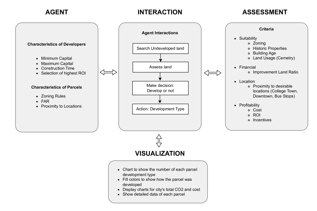
Manuscripts detailing the results of the ABM are presently under review and are embargoed at this time. The ABM model is freely available on GitHub. See the Handbook below for more details.
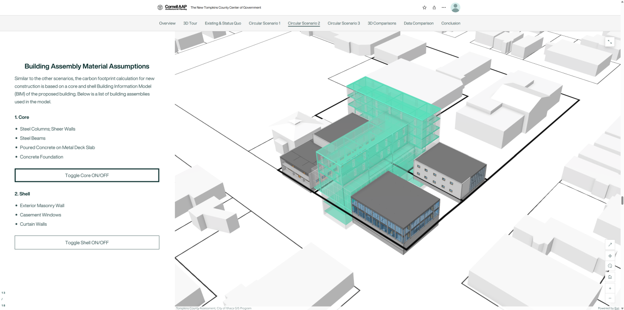
Phase II. Storymapping with 3D Models and Life Cycle Analysis of Case Study Sites
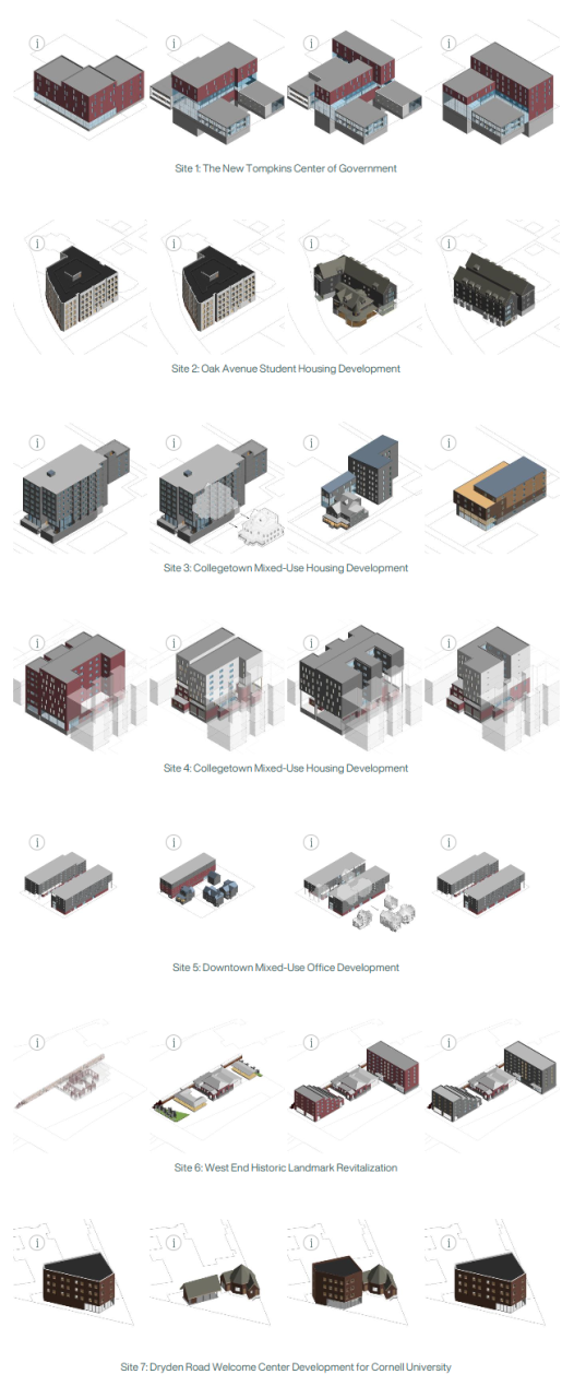
The second phase was devoted to 3D Modeling, LCA analysis, and the development of an ESRI StoryMap web platform. This second phase involved the creation of 28 scenarios in Revit and analyzing each one using Tally for Revit and the CareTool.
View a Story Map with links to each of the case study sites here.
Lessons from the two phases are available here:
Project team
We would like to acknowledge the entire project team, including: Farzin Lotfi-Jam, Realtime Urbanism Lab (PI, Co-PI); Jennifer Minner (PI, Co-PI), Just Places Lab; Courtney Bower (Co-PI), Just Places Lab; Xinyu Tang, Realtime Urbanism Lab; Jebreel Bessiso, Realtime Urbanism Lab; Jessica Kaiman, Realtime Urbanism Lab; Hung Ming Tseng, Realtime Urbanism Lab; Sun Ho Synn, Realtime Urbanism Lab; DongHak Lee, Just Places Lab; Vanessa Yang, Realtime Urbanism Lab; Landon Hale, Realtime Urbanism Lab; Nisarg Shah, Just Places Lab; and Ash Kopetzky, Just Places Lab.
Acknowledgements
We would like to thank Christine O’Malley of Historic Ithaca, Andrew Boghossian of Finger Lakes Reuse, and additional partners in the Circularity, Reuse, and Zero Waste Development network, Billie Faircloth and Lori Ferriss of the Built Buildings Lab, Holt Architects, Alejandro Fuentes Arias, as well as the developers, architects, and preservation professionals who participated in interviews, focus groups, and surveys that informed this research.